JiLuDB
ExploreAll recordsTimelinePlacesMapAbout
Search records, people, places…
Public site
LANG
ExploreAll recordsTimelinePlacesMapAbout
JiLuDB

Explore the World's Records

GLOBAL RECORDS DATABASE

HomeAll recordsTimelinePlacesAbout

© 2026 JiLuDB. All rights reserved.

Previous recordLongest Explored Underwater Cave SystemNext recordRegion with the Most Active Geysers
←→ Browse13 / 421Back to list
Immersive view

Record #00413Nature archive

Longest Fault in California

The San Andreas Fault is California's longest fault, described by NASA Earth Observatory as about 1,200 kilometres long. USGS describes the broader fault system as roughly 1,300 kilometres, reflecting a different system-level scope.

Verification status
View verification details ↗
Last updated
2026-11-06
Category index

Current Record

about1,200km

Current record value

Previous recordLongest Explored Underwater Cave SystemNext recordRegion with the Most Active Geysers
Back to list
Previous recordLongest Explored Underwater Cave SystemNext recordRegion with the Most Active Geysers
Holder
San Andreas Fault
Location
CaliforniaSatellite view · Google Maps, USA · San Andreas FaultSatellite view · Google Maps · United States
Start date
—
Record status
VerifiedView verification details ↗Report an issue
OverviewRecord historyRelated recordsSources

Overview

Archive Note

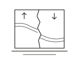
The San Andreas is a right-lateral strike-slip fault network marking the boundary between the Pacific and North American plates across much of California. The geological fault is not visibly exposed as a continuous cliff or scar along its entire length, and its branches vary in structure and accessibility.

NASA's satellite and radar-topography presentation of the Carrizo Plain explicitly identifies the approximately 1,200-kilometre San Andreas as the longest fault in California. USGS describes the San Andreas Fault System as a roughly 1,300-kilometre transform boundary. The approximately 350-kilometre rupture in 1857 was an event-specific rupture, not a measure of the entire fault's length.
Key information

NASA-reported length
Approximately 1,200 km (roughly 800 miles)
USGS fault-system extent
About 1,300 km
Fault type
Right-lateral strike-slip, Pacific–North American plate boundary
Well-defined trace
Wallace Creek in Carrizo Plain
1857 event rupture
About 350 km, not the overall fault length

Record history

1 Milestones
  1. —about 1,200 kmSan Andreas FaultCalifornia, USACurrent Record

Related records

Continue Exploring
01

Nature · #00287

Lowest Air Temperature Recorded on Earth

Verified

-89.2 °C

Vostok Station

02

Nature · #00080

Largest Earthquake Recorded by Seismic Instruments

Verified

9.5 Mw

1960 Valdivia earthquake

03

Nature · #00289

World's Tallest Active Geyser

Verified

over 91 m

Steamboat Geyser

Sources

Evidence & References

Verification basis and limitations

Verified

The record conclusion has sufficient verification support.

Basis: direct confirmation by an authority

NASA Earth Observatory's 2000 San Andreas Fault in the Carrizo Plain article explicitly identifies the approximately 1,200-km San Andreas as California's longest fault, supporting both the regional comparison and the recorded length. A 2018 USGS study describes the broader fault system as about 1,300 km; these figures should not be represented as the same precisely defined measurement. Exposed surface faulting is prominent locally, not throughout the entire system.

Comparison boundaries still under review

This is a California regional record, not the world's longest fault. NASA's roughly 1,200-km figure and USGS's roughly 1,300-km system-wide estimate have differing scope. Total fault length must not be presented as a continuously visible exposed surface trace.

Verification assessment
2026-11-06
Last editorial review
2026-11-06

Current Entry identifies the current entry in this archive; it does not establish that the record is still held today.

Source IDSourcePublisherLink
SRC-001San Andreas Fault at Wallace CreekOfficialENRecord topicUS Geological SurveySRC-002The San Andreas Fault System—Complexities along a major transform fault system and relation to earthquake hazardsAcademicENCurrent recordUS Geological SurveySRC-003San Andreas Fault in the Carrizo PlainOfficialENCurrent recordNASA Earth Observatory

The record value on this page is organized from the public sources above. Measurement methods may differ; JiLuDB follows the unified method described for each entry.

Public feedbackFound a data issue?If a fact has changed, the data is incorrect, or you know a more authoritative source, submit feedback.Submit feedback

Help keep the archive accurate

If a fact has changed, a value is incorrect, or you know a more authoritative source, leave a note. Feedback enters an administrator review workflow and never edits a record directly.

Verified
Nature

ARCHIVE VISUAL / 01

NOT TO SCALE

  1. Home
  2. /All records
  3. /Longest Fault in California

Recording humanity Understanding the world / GLOBAL RECORDS DATABASE